Life is an ultramarathon

To content | To menu | To search

Keyword - OFF

Entries feed - Comments feed

Wednesday, March 16 2011

1908 Olympic Marathon

As you might know, it's during the Olympic Games of 1908 in London that the current 42.195km marathon length was set. After reading an excellent article by M. Polley [1], I've tried to map the course on Google Earth (also on GoogleMaps). It's not trivial to follow the original route in some places, and even completely impossible toward the end, where the White City Stadium has been replaced by the BBC Media Village a few decades ago...

On Sunday, Alessio and I decided to attempt the course casually. We took the train to Windsor and started running gently towards Eton. The only actual remaining feature mentioned by [1] is a milestone in Eton, that we unfortunately failed to notice...

marathon1908-start_450.jpeg
Two runners at the start of the 1908 Olympic Marathon (Windsor Castle).

Nowadays, the route would definitely not be considered as runner-friendly, as pointed out by Fiennes. A long stretch of dual carriageway between Slough and Uxbridge is rather noisy. After a quick sandwich break in Ruislip we headed towards Harrow, where a commercial centre has been built in place of the original route path.

Overall, the route is not hilly, but not flat either! We could feel the gentle climbs towards the end. After Wembley Stadium, we crossed a major train line hub at Harlesden, from which it was impossible to follow the original route. We passed by Dorando Close, and finished on the "souvenir" line painted on the pavement of the BBC Media Village, in front of a table of Olympic Medallists. Nice run!

marathon1908-finish_450.jpeg
Re-enactment of the 1908 Marathon finish with a twist: what is Dorando hadn't been helped by the officals?

Ultra old marathon.

[1] Martin Polley, From Windsor Castle to White City: the 1908 Olympic marathon route. The London Journal, 34(2), pp 163-178, July 2009. [online].

Pictures courtesy of Alessio.

Thursday, June 25 2009

Paddy Buckley Round (attempt)

Last week-end, I went to Snowdonia with the Chameleons in order to attempt the Paddy Buckley Round. This is an arbitrary tour of most of the highest summits of the Snowdonia National Park. It features 104km for 8,700m of ascent. Runners usually aim to visit all 47 summits in less that 24 hours, but it can alternatively be completed as a 4 days fast hike. Our overall idea was to train for the Petite Trotte à Léon (PTL) in close-to-reality conditions. In short, a team effort over several days, with the same equipment, and including navigational aspects. With that in mind, the goal wasn't to be as fast as possible, in particular as we would try to spend a night out.
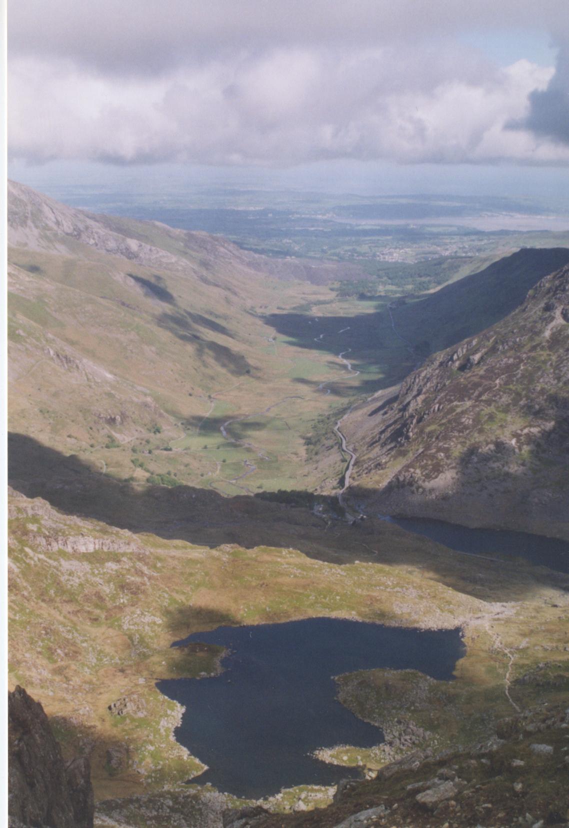
The Moelwynion

We started on Saturday at 12 noon from Capel Curig towards Moel Siabod and soon realised we wouldn't be fast enough to make it home reasonably early on Sunday. With that in mind, I felt slightly demotivated very early in the run, which is not a good thing in ultra. The main reason for such a slow progress was the very boggy terrain, forcing us to meander a lot and wasting energy at every step. At some point, I managed to sink up to the crouch... Our feet were soaked from the start to the end. The weather was slightly adverse, with occasional drizzle and hill fog, but it wasn't too bad. The Moelwynion range doesn't seem very touristy compared to the northern mountain ranges and we only saw a few hikers.

Night with the bothy bag

We decided to stop at midnight near Aberglaslyn. The night was rather unpleasant. The bothy bag is a kind of large waterproof bag to be used in case of emergency, and this one is designed for 4 to 6 people to sit. It is very small for 3 people to lie down, and you end up very intimate with your run mates... Good point for team bonding :) .We used our walking poles to raise a bit the "roof". Because of its waterproof nature combined with very poor ventilation, it got very wet inside, and the cold condensation water dripped on our faces the whole night. On top of that, I felt like I couldn't breath properly (not sure whether this is just an impression or if the level of CO2 was that high), so I ended up moving outside, as Leo did earlier in the night. I got quickly welcomed by a swarm of midges, which forced me to sleep face down with only my mouth out. Nice.
To make things a bit more lively, Sven woke up as I was still inside and shouted: "Shhhhhhhhhhh!!!", and then "Haven't you heard?". The night was dead silent, but Sven seemed extremely preoccupied, and carried on shouting "Shhhhhhhh!!!". I replied that really there was nothing wrong. Only after a bit more shhhhhhing, Sven drifted back to a quieter mood. He told us later he had dreamed he heard a strange noise, and as he poked me with his arm, he though I was ... a pig attracted by some food in the tent and he wanted to scare it away! Nice to know I feel like a pig when I sleep. Thank you Sven.
Nevertheless, the night helped us to recover, and although we had planned a 4-hour break, we stayed there for five-and-a-half.

The Eifdnydd

Our legs were not too bad in the morning. However, the navigation became harder as we were more tired and not too keen on taking prompt decisions. Moreover, most of the time there was no clear path and apparently very few people were attempting some of the minor summits. Therefore we spent quite some time in route planning, wondering on top of each hill what would be the best route to get to the next one. I can't imagine how we would have done that with a bit more hill fog. On top of that, the midges were following us, buzzing around every time we stopped, and thus forcing quick decisions - I'm not sure whether this is actually a good or a bad thing. We had some repellent, but the evil creatures didn't seem to be aware that it was supposed to scare them away :) Anyway, I'm still itching three days later!
Slippery wet stones near Y Garn slowed us down a bit further. When we finally arrived in Rhyd-Ddu, Snowdon was in the clouds (as it's been the whole week-end), we lost a bit more motivation due to the miserable weather and eventually decided to come back home...
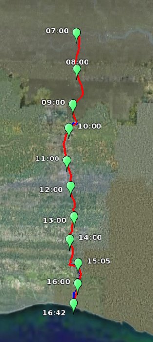
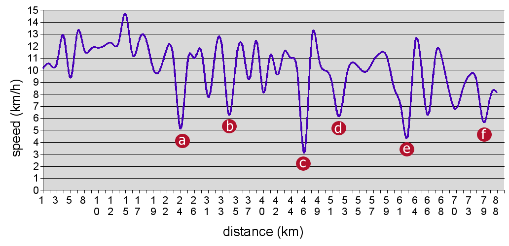
Split times

Distances and summit list adapted from the wikipedia page. Note: we actually went through all the summits, but I didn't bother recording the times of some of the minor ones.

Summit Altitude Distance Clock time Time
Capel Curig 200 0 12:15 00:00
Carnedd Moel Siabod 872 4 13:30 01:15
Clogwyn Bwlch-y-maen 548 7

Carnedd y Cribau 591 8 14:15 02:00
Cerrig Cochion 550 11 15:15 03:00
Moel Meirch 607 12 15:30 03:15
Ysgafell Wen 650 14

Mynydd Llynnau'r Cwn 669 14

Three Tops 672 15 16:20 04:05
Moel Druman 676 15 16:35 04:20
Allt-fawr 698 16 16:50 04:35
Bwlch Cwmorthin 470 19

Foel Ddu 458 20 18:15 06:00
Moel-yr-hydd 648 20 18:30 06:15
Moelwyn Bach 710 23 19:15 07:00
Craigysgafn 689 23 19:30 07:15
Moelwyn Mawr 770 24 19:45 07:30
Cnicht 689 28 21:15 09:00
Aberglaslyn (arrive) 5 35 23:30 11:15
Aberglaslyn (depart) 5 35 05:00 16:45
Bryn Banog 529 38

Moel Hebog 782 40 07:45 19:30
Moel yr Ogof 655 41 08:25 20:10
Moel Lefn 638 42 08:45 20:30
Y Gyrn 452 44 09:45 21:30
Mynydd-y-Ddwy-elor 466 44

Trum y Ddysgl 709 46 10:35 22:20
Mynydd Drws-y-coed 695 46

Y Garn 633 47 11:30 23:15
Rhyd-Ddu 190 50 12:15 24:00

Gear testing
Fundamental pieces of new equipment were tested on the week-end:
  • The Quechua S10 Ultralight sleeping bag served its task pretty well. Rather warm despite being slightly damp and packed in only 900g, Decathlon ends up doing good stuff sometimes.
  • I bought a OMM Classic Marathon 25L backpack (*), as I needed something a bit bigger than the one used on the UTMB in order to get the bothy and sleeping bags in. It's quite light (725g), well conceived and looks good. Pockets and nettings are easily accessible, relatively waterproof, and a half-length sleeping mat is included in the back! It's also quite comfortable. But I'm not sure how rip-resistant it is, as I managed to tear a bit of netting on a fence already. I have to admit I'm usually tough with my gear.
  • The Lifesystems Bothy 4-6 does the job it's designed for. And nothing else.
Lessons

Team effort - no big clash and we managed to stick together the whole time, so that's positive overall. However, we should probably rely more on each other for motivation. Also, I've been leading the way quite a lot, and I guess it would be better if we took more even turns. The decision taking process is far from optimal and rather slow. The route choices were especially difficult, as we had different priorities: shortest distance, safest route, minimal ascent, less technical, ...
Navigation - paper maps should be laminated! My old OL17 has seen quite a lot already (then, and then), and is now turning into papier maché... Or better, small route cards with pre-marked bearings should be used. I already knew that from the Hardmoors, but it always takes time to learn the lesson.
Night - the bothy bag should be used only if required (that's what it's intented for anyway). We'll probably try to sleep in refuges when/where possible.

Conclusions

In the end, we covered only of 2 the 5 main ranges of summits and half the distance (ie. 50km). We missed Snowdon, the Glyderau and the Carneddau ranges, which are more rocky and probably more similar to the alpine conditions on the PTL. We ran for 18 hours 30 minutes, plus longish break on challenging terrain, so it's not all too bad. But it's a bit disappointing to be fair. We could probably have done the Snowdon range as well in under roughly 24 hours (not considering the night).
According to the guide book, there are three kind of runners attempting the route: those who know every single stone on the route, the navigation geniuses, and those who don't really know what they're doing, ie. us :) ... This was quite clear. We came there relatively unprepared for the task (route planning, maps, ...). As Leo said as we started running: "Don't forget who's idea it was to do this". Well, it was mine, and I should probably have planned it better.
Anyway, now that we've tried, I can't stay defeated. It's getting personal... There will be more attempts, and there must be a success one day! Hopefully, further attempts could be much easier, given that we know most of the route (I'm already familiar with the Glyderau and Carneddau).

Ultra team training.

(*) I bought the bag online at backpackinglight.co.uk, as many retailers were out of stock until late July, and I have to say I'm pretty happy about the company. Apart from the free podcast CD and free sweets shipped with the parcel, they also bother to include a short hand written "personal" note and call you a couple of days later to make sure the parcel has arrived. That's what I call working on customer relationship!

Wednesday, September 5 2007

London to Brighton GPS route on GoogleEarth

Well, everything is in the title... I've been increasingly asked to use GoogleEarth for my para-academic activities. Just to see how it looks like, I've imported some old GPS track into GoogleEarth. Note that the free version doesn't allow that directly, but a couple of lines of Python can convert very easily any route file into KML. The blue sections were missing and have been drawn by hand. Enjoy.

GoogleEarth - London to Brigthon
Click to download the file


Ultra track.

Monday, July 9 2007

Eastbourne - Brighton

On Saturday I did my last long run before the UTMB. I ran from Eastbourne to Brighton following the South Downs Way in the hills, nearby the south coast. The route I chose was about 47km long. The aim for this week-end was to go to North Wales, but for various reasons I couldn't make it. Moreover, I was pretty tired by the end of the week and I only decided to go there on Friday night. Very little preparation !

The weather was quite good, very sunny but also very windy. As the wind usually comes from the West and I was mostly heading West, I had the wind in my face most of the time, or at best on my side. Unfortunately the relatively cool air combined with the wind made me forget that the sun was actually pretty strong. I'm now covered in sun burns...

The run went pretty good, although not very fast. I took my poles with me because the aim was to train in similar conditions as on the UTMB (*). I think they were a bit useless though, because the slopes were never steep enough to make good use of them. Moreover it's always a hard decision in this sort of gentle slopes whether I should run or walk... On the 3 Forts Marathon I decided to run all of them, but I took it much easier on this run. I could see lots of people seemed really suprised I used poles. A bit like when I was hiking in the Alps with them 5 years ago. Some even asked me whether I was injured !

My water tank started to leak at the beginning of the run, wasting the precious liquid and turning my map into papier maché. Well, better notice now than in the middle of the night on the Col du Bonhomme...

I eventually arrived in Brigthon after running 5h40. Compared to 4 hours on the 3 Forts Marathon, which follows a similar route, it doesn't look very good. I'm quite satisfied though because it was not prepared at all, because I had to navigate and find water, because the wind sucked a lot of power and because out of a competition I took more time to enjoy the landscape.

Ultra burnt.

(*) Mike: You'll be glad to learn that I haven't hit any nice Englishman in the **** with them :)

Monday, December 4 2006

London - Guildford: the Mommas' Pilgrimage

On Saturday, I ran from home (London, Hammersmith) to Mommas' Palace (Guildford). That's a nice 60km run along the Thames from London to Weybridge, then along the Wey River up to Guildford.

Given Mommas' aura, several pilgrimages have already been carried out. When he lived in Weybridge, we walked from Hyde Park by the Thames Path and Richmond Park (30km - see Original ultra feeling). Then Mommas decided to make it harder and moved to Guildford; we walked from Surbiton (36km) (*). This time Mommas gave me the force to run the whole way at once. The target was set to 6 hours.

When I left at about 8am, the clouds were threatening and I expected some rain on the way. But I didn't even get a tiny drizzle. The temperature was perfect: about 10°C. From the beginning I used the so-called Cyrano method: I walked 1 minute every 10. These micro-breaks allow to rest the muscles and potentially reduce the speed decay and avoid injuries. Moreover, they can be used to eat and drink at regular times. Hammersmith, Mortlake, Kew, Richmond, Kingston-upon-Tames, Walton-on-Thames, Weybridge: the section along the Thames went quite smoothly. I knew most of the path, except the swing around Hampton Court Park. Just before that, in Kingston, a runner tried to trick me and told me the tow path was following the South Bank. Fred and I have been there: no Thames Path on the South ! I trusted my map and my experience and crossed to the North Bank. Good choice ! Strangely I got some blisters and frictions at various places, but as often in ultra-running, those disappeared quickly. After 3h15, I was in Weybridge (35km).

At Weybridge, I left the Thames to follow the Wey tow path. This path is actually part of the E2 European Long Distance Path, which follows the GR5 in France. I didn't run quite as far as Nice, though :) The Thames was rather high, and so was the Wey. When I walked it with Fred, the Wey was just a small stream on the side of the Wey Navigation (a canal seconding the Wey). This time, not only the Wey Navigation was filled in to the top, but the Wey was a powerful river occupying all its bed. In fact the locks were not in use because of the flood. Last time, it was recommended to use them economically due to the drought!
From this point, the sun started to shine unexpectedly. That also means more water consumption, and I had to stop at a pub (The Anchor) to get some drink. I don't know why I did that, but I ordered a pint of ice-cold coke that I drank in less than a minute. Objectively, the best way to throw up, but it went surprisingly well ! The path was quite muddy and some sections in the riparian fields were really squelchy, difficult to run ... The Wey was on the way (**). I progressively started to feel stiff. Ache in my right hip and in my left ankle reminded me old injuries. I also experienced a novel form of pain: a sudden, intense, sharp, localised pain in my right calf. I think it's actually a sort of cramp. After 50-55km I had to walk every 7.5 minutes and even every 5 minutes. But when I was running I was still quite fast. That's the Cyrano effect. To make things a bit harder, Mommas obviously doesn't live nearby the river, but on a hill ... I planned to walk this last ascent, but surprisingly while approaching Guildford I felt much better and could run continuously even uphill. It's again a proof that pain, cold, and other unpleasant feelings are just a conception of mind. When you know you're about to arrive, the psychic removes all the pain.

Arrived after 6h05, mission accomplished ! Bredele, mulled wine and crêpes for replenishment :)

Ultra pilgrimage.

(*) This paragraph really looks like a short literature review (related work) at the beginning of a publication... I'm writing all day lately!
(**) I really needed to do this joke, sorry...

Tuesday, August 1 2006

"Shock week-end" in North Wales

Last week-end I went to my favourite mountains in the UK for a training week-end in real conditions: 2 days of hard running in the hills.

When I left Betws-y-Coed on Saturday morning, after a full Welsh breakfast (1), the weather was relatively fine. I managed to run up to Capel Curig in the woods and meadows as a gentle introduction. The hard bit started from there, climbing the ridge up to Glyder Fawr (999m). Lots of ascent, lots of very steep descent in the rocks too ! This was a proper Alpine path, and actually even the UTMB route is not so exposed and technical. The time to arrive back down to Llyn (Lake) Ogwen, the weather started to be more threatening. I decided to try to climb quickly Carnedd Dafydd, in order to do the scramble before the rain. After 300m of quick ascent, I had to withdraw as the wind and the rain were far too strong (wind forecasted 100km/h). The horizontal rain was painful and it wouldn't be reasonable to keep on going, not only for the scramble but also probably later on the ridge. I then came back in the heavy rain through an escape route. Regarding to my previous days out in the area (summer hike, winter hike), it seems that the weather in Wales is quite moody ... Anyway, that was around 35km and 1700m (6h30) for the day.

On Sunday, after my second full Welsh breakfast (2), I left for a more gentle run. My thighs were a bit stiff at first (some would say painful) but after a short warming up, it went pretty fine. I headed towards the lovely Lake of Llyn y Foel that I reached after a couple of showers. Then back down to the youth hostel in the wet rocks that my shoes didn't particularly appreciated. That was not a very long run (around 15km +500m in 2h30), but it's very good to see how fast I "recovered", and also how I felt like keeping on running all the time.

I also used the occasion to test a couple of items:
  • Raidlight mini-gaiters were pretty good to avoid mud and small stones to get into the shoes. They qualified for the UTMB :) .
  • Raidlight shoulder strap bottle - there are 2 kinds of ultrarunners: the bottle aficionados and the water tanks ones ;) . So far I was in the latter group. The advantage of the bottle is to be more accessible and much easier to refill. But this one was particularly unstable, whatever the website reads, with the bottle hitting my heart continuously while it was more than half full. Maybe my straps were not tight enough or maybe not the right shape, I don't know. I'm not sure yet if I will take it with me to the UTMB.
  • SiS Go gel were a pretty good surprise. They actually taste like a sort of light jelly: this is much better than my usual PowerGel which are extremely sweet and sticky (3). Only drawback, the Go gels contains only 88KCal (against 110 for the PowerGels), while being sensibly bigger. Anyway, I think they qualified as well for the UTMB.
(1) I know I shouldn't eat that sort of things just before running (see Amsterdam Marathon), but I also need to train my stomach to be more resistant to change. Also, the run went fine anyway.
(2) A full Welsh breakfast apparently consists of: deep fried bread, baked beans, fried egg, fried mushrooms, tomato, fried bacon and sausage. Can anyone tell me the difference with an English breakfast ?
(3) And they also don't have a website with loads of useless and slow flash rubbish...


Ultra training.

Monday, June 26 2006

Test marathon along the Thames

I wrote a couple of months ago:
I'll try to run the UTMB only if I manage to run a marathon with good feelings, whatever the time, by the 30th June.
I then had a plan to increase progressively my training distance and to run a marathon on the last week-end of June. The second half of this plan was a bit messed up for various reasons. One of them is that I start to feel fed up with Hyde Park and pre-formatted training in general. I just want to run long distances on novel paths. Anyway, I had only ran up to 19km so far and planed to run 32km on the week-end of the 17th. But when I woke up on the Saturday morning I decided to go for 42.2km.
I took my water tank and left at 8:30. I crossed Kensington gardens, went down High Street Kensington up to Hammersmith where I caught the Thames Path. I then followed the Thames up to Kingston, where the GPS gave me 21.1km. The outward was pretty nice, good feelings and still relatively fresh under the trees and bushes. I made it in around 1h50, which is nothing outstanding, but not too bad either. However, from the middle I started to feel pretty dizzy, probably a bit dehydrated. The return was then quite hard, walking long bits far too often, but I managed to finish anyway in 4h20 (ie. 2h30 for the second half-marathon, arg! ). At least, I was just right on time to watch the airplane show for Her Majesty's birthday...

Good points:
  • My hip didn't complain, neither during the run nor the following days - great news !
  • I tested the so-called Cyrano method (*) to save up the legs. It consists of alternating running and walking in order to use different kinds of muscle cells. I started by 1 minute walking every 15 minutes. Then it was more once every 10 minutes. It is very important to do that since the beginning when everything is fine, not only when muscles start to be painful. The method worked quite well, as I didn't feel too much pain in the afternoon and the following days.
  • Porridge went pretty fine.
Factors that didn't help:
  • The temperature was already too high for such a run.
  • I just started to train seriously again.
  • I had no psychological preparation, I just left like that (and not a long night either).
What's still wrong:
  • I'm clearly not at the level I was last year on that kind of distance. During London to Brighton (same kind of conditions), I ran the first 42km in about 4h, and didn't decrease so much afterwards.
  • I'm still not very good at managing my drinking/eating during the race.

Yesterday I went with Fred to Guildford (where Mommas lives) from Surbiton. That's a lovely 36km walk along the Thames and the Wey, in the meadows and the reeds that went pretty easily in 9h, including breaks. Slightly encouraging as well.

So, unfortunately, no firm conclusion about my participation at the UTMB yet ... To be decided this week.

Ultra test.

(*) named after the nickname of a French ultrarunner that made a couple of experiments around this method - Run less to run more (in French).

Friday, May 5 2006

London to Brighton (running version)

This article is a adaptation of 'live' entries on my previous blog and some extra information.

On the 05th November 2005, I went again to Brighton from London, but without my bike this time (as it's been stolen...). I followed the roads, mostly the A23 and the B2036. I had to be at the same time the organiser, the volunteers and the runner. Which means that I had to navigate, to find some water on the way and ... to run ! This is what ultrarunners often call an 'OFF' as it's out of any kind of organisation.

I started from Westminster at 7am (official Big Ben time). I ran through Brixton, Streatham, Croydon, Purley and Coulsdon (km 23) before I started to see the countryside. Panoramas from Farthing Downs were pretty nice. Then Chaldon, Redhill (km 35) where I bought my first water refill. From this point I started to swap between short walks and longer runs. Salfords, marathon in 4h02, Horley (km 44). I started to feel a bit tired, so I had a short rest in a meadow nearby the road. Some policemen stopped to ask me if I was ok and then chatted a bit. This comforted me again to think that British policemen are much kinder that the French ones.
I continued to Crawley and started to have cramps after that. Immediately doubt took my mind, I looked at the map where was the next train station, etc. But, as often in ultras, after 10 minutes walking I felt fresh, running, enjoying the landscape, and never thought about withdrawing again ! :) Balcombe, Cuckfield, Ansty. On the narrow roads surrounded by hedges, I had to be very careful with cars, and once I was so close to the hedge (the car didn't leave me much space) that I didn't see a branch and fell down. Nice bleeding knee. At Burgess Hill someone stopped to ask me if I was fine. Then Hassocks and Ditchling, just before the ascent of Dictchling Beacon (150m elevation gain on a steep road) where I walked more than I ran. Pain in the legs started to increase and the descent to Brighton was not very pleasant. Finish at Brighton Pier at 4:42pm, just before the night.

GoogleEarth - London to Brigthon
Click to get the GPS record on GoogleEarth.


I took 9h42 to complete these 90.5km (GPS: 88.6km) while I expected around 10h. That's an average speed of 9.3km/h or 4h30 for a marathon, not too bad. During the official race, the time limit is only 9h50 (but the route is 1 or 2km shorter).

The following morning, after a not-so-good night, my legs were very stiff (not to say painful) especially while going downstairs or sitting down. Even my upper body (abds, shoulders, arms) was quite stiff. Funny to think that I felt better after 35h30 on the UTMB... But the London to Brigthon run, however shorter, was much more intense.

I got a nice GPS track of the route, although I miss the end because I ran out of batteries. I just acquired a couple of waypoints from Hassocks, not very precise. This is the speed graph of the run. Speed was integrated on 500m sections. Slow motion zones can be explained by the following:
  • a: first stop at the beginning of Farthing Downs
  • b: water stop at Redhill
  • c: short rest after Horley
  • d: cramps and moment of doubt at the exit of Crawley
  • e: water stop at Cuckfield
  • f: ascent of Dictchling Beacon

London-Brighton speed
click for larger image

It's interesting to distinguish between 3 main parts: the first third (start to a) virtually always over 10km/h, the second third (a to d) at the constant average speed but with lots of slower parts and the last one (d to the end) slowing down constantly.

A couple of days after this run, my right hip started to be achy. I've then stopped running, although I can't say it was painful. It sometimes starts as soon as I wake up, sometimes I have to walk a bit. It's mostly located in the hip, but sometimes runs from the lower back down to the foot. See the following posts about my slow recovering:
Ultra free run.
Powered by