Life is an ultramarathon

To content | To menu | To search

Keyword - hiking

Entries feed - Comments feed

Tuesday, April 20 2010

Hiking boots vs trail running shoes

I've been hill-walking and hiking as far as I can remember, and have been wearing hiking boots for that purpose (nearly) as far as I can remember too. It's always been quite obvious to me: on rough, unstable terrain, you need good ankle support and decent grip. I would believe people hiking in trainers to be unaware of the risks and rather foolish.

But things started to change in my mind after my first UTMB in 2005. Indeed, I came to realise that I had actually covered the entire length of a long-distance alpine hiking path wearing trail running shoes, whereas I would have never hiked it in trainers. The fact I was running as opposed to hiking doesn't change anything to the risks associated with wearing inappropriate footwear. If anything, it's even worse as you go faster, by night and sometimes in extreme fatigue. And what about fell-running on the PTL or in North Wales? Was that foolish? Probably not, it's just a matter of knowing how to use the ground in the mountains: fell running shoes' grip is as good as most hiking boots, and if you're careful on foot placement, there's little risk of injury.

On the other extreme, I saw loads of people wearing hiking boots on the grassy hills of Seven Sisters on the south coast a few weeks ago. It might be slightly hilly, but the ground is really soft and smooth all the way. Ironically, I was walking in trail running shoes on that day :) . So why bother with heavy leather hiking boots if not to be seen as a hiker? Maybe to feel like a hiker?

Indeed, we've already discussed on this blog the fine line between running and hiking, to which I should add mountaineering. I believe this fine line is more a matter of state of mind than actual speed. And it looks like wearing a specific type of shoes has become a way to materialise this state of mind rather than a technical necessity: "I wear hiking boots to show and to convince myself that I'm not 'just' having a Sunday stroll: I'm hiking". L'habit ne fait pas le moine (you can't judge a book by its cover).

In general, when people get "serious" into some kind of activity, they tend to go a bit over the top in terms of gear (sport equipment brands do help). Hiking/mountaineering boots were invented at a time when sport shoes were non-existant by people requiring extra grip and protection to progress in truly tough environments. But with the range of lighter trail shoes available nowadays, I'm not convinced hiking boots provide any significant advantage on easy-going paths, might they be long-distance such as the Tour du Mont Blanc, let alone Seven Sisters.

Now that I've got a range of running shoes for every situation (road, trail, fell) on top of my hiking boots, I'm tempted to re-evaluate what footwear is really adapted for each outing, based strictly on the actual route technicality and not on the denomination of the event (stroll, marathon, hike, trail run, ...). That said, I'm not sure in what sort of context I should wear my hiking boots any more. Apart from bogs and snow, I don't see much scope for them. Fell running shoes are much lighter and will do as well otherwise.

Has wearing a specific type of shoe become a (self-)statement more than a necessity?

Ultra shoes

Thursday, April 3 2008

The tortoise and the hare

Some people including myself, suggested that ultrarunning is some sort of extension to hiking. Just as if hikers progressively build up their walking pace and end up running. I think this is actually only partly true. It depends how and why you like hiking.

The hare

I've noticed that during most of my hiking trips, I try to see as much scenery and attractive features as possible in the given time. This leads to walk fast, climb up to the summits and dive down to the gorges and lakes. There are clear spatial and temporal objectives, set more or less consciously. I want to climb up this mountain, I want to sleep at this lake tonight, etc ... To some extend, this is fairly similar to race conditions, where I want to pass this checkpoint at that time, etc ... Everything is planned beforehand and I'm adrenalin-driven towards a set of objectives. I'm not running, but I'm already a hare in my mind.

The tortoise

Another way to hike is not to bother too much about location and time. Just walk and see. Change plans on the way. Add extra detours. Rest somewhere for sometimes. This approach is advocated by many hiking guide books. Believe it or not, this happens to me as well. When I'm depressed and I don't have the mental energy to chase after an objective. Or when I see the end of a multi-day hike approaching and I don't want to rush it anymore, to stay longer. Being the tortoise is not as easy as might look. Because less planning also means more uncertainty that could potentially lead to stress if not well handled.

The tortoise approach is not reserved to hikers, though. Many non-competitive ultra-runners are also tortoises in their mind. This typically happens when you don't have a time objective in mind and want to enjoy the scenery. The race is there, but not considered as such. It's an aid to the run (water stations, route marking, massages, ...) and a nice way to meet like-minded people. It's worth noticing that many hares on the UTMB reduce this event exclusively to a competition and suggest tortoises to run around the Mont-Blanc at another date if they're not happy with it. They completely miss the point and just don't see that the event is much more than a race.
Some event organisers already caught this trend. Many ultra-races are open to tortoises, with a fairly long time limit. Even some marathons now welcome walkers by extending the time limit to 8 hours.

Being hare or tortoise is not so much a matter of physical capabilities in the end, it's mostly a mental state. Hares can hike and tortoises run.

Tortoise and hare
Tortoise and hare in summer 2005


The hare's need for symbols

Whether it's hiking or running, the hare approach often needs strong symbols. Such symbols push people forward by supporting and augmenting the objectives. They add extra motivation on adrenalin-driven races and create virtual objectives on hiking paths. They could be for example running from a city to another, cross a mountain or follow a river. These symbols are one of the reason why races such as the UTMB became so popular so fast: around the highest mountain in Europe, across 3 countries... These same symbols drove lots of attention and admiration to the "Tour du Mont-Blanc" long-distance hiking path before the race was first organised. For example it was described on TF1 (a French populist TV channel) as one of the most famous and hardest hiking path. This is clearly not true. While it's not an easy path, several French long-distance hiking paths are technically harder (GR54 and GR20 to give only 2 names), not even considering the rest of the world... This shows how the symbols can augment the physical reality of a hike or a run in the hare's mind.

A symbol I quite like is to join two places with my feet. Modern transportation methods are more or less a form of teleportation, as you are very little involved in the navigation and certainly not immersed in the environment. And you miss a lot. The world is not continuous anymore, but made of a set of discrete points. Running or hiking makes you feel like you reconnect these points, and gives a very good feeling of belonging to this continuous space. While running from London to Brighton for example, I've seen every meter of ground in between the two cities. Note that this also applies to smaller scales; for example walking in cities instead of taking the tube.

The tortoise's need for simplicity

On the other hand, the tortoise seeks for the simplicity of the journey. Running and walking are simple activities by essence. Simplicity can mean various things depending on the context and person. Hiking with a tent makes things easier, as you are free to sleep wherever you want, thus reducing the need for planning and reaching objectives. Sleeping in refuges also simplifies things, as there is less equipment to carry and you get to meet more people.

The best of both world

And often hikers/runners are tempted by both the hare and the tortoise. I've been thinking of running the whole length of the Thames (300km) in one leg. This is the most extreme option (at one end of the scale) that would probably take between 40 and 50 hours. In order to see more landscape and therefore run during daylight only, I've also thought about splitting the journey into 3 consecutive running days of about 100km. This is a bit of a softer option. But it still involves major milestones and fair daily mileage. It's still a hare option. Lately, and somehow strangely, I've been thinking seriously about walking along the Thames following a day-to-day basis, without real plan. Without really knowing where and how to sleep the next night. My new very-waterproof clothing may have helped this thought, as it would allow to sleep outside anywhere by virtually any weather and without any further equipment (such as sleeping bag and tent) that requires more careful planning.
Note that running in the rain is often perceived as a form of escape: the hare seeks the finish line to get a hot shower. Hiking in the rain shouldn't be seen as an escape. The tortoise feels comfortable in the rain. The hare mentally projects himself towards the next checkpoint whereas the tortoise enjoys the current moment.

The same person can clearly be hare or the tortoise or anything in between at a given time. Now, is it possible to become simultaneously the hare and the tortoise? Get the best of both worlds? I'm actively looking after that. I don't think I've reached this stage yet. This probably requires a bit more experience too ...

Ultra confused.

Saturday, August 18 2007

Tour du Parc National de la Vanoise

Update 21/09: pictures and a bit of text.

A couple of weeks ago, Rachel, Bastien and I went to to the Vanoise National Parc for a bit of a hike. The Tour des Glaciers de la Vanoise is a classic in the region, we doubled it, as shown on the map below. The "outward" journey followed the virtually mythic GR5 from Modane to Val-Claret whilst the "return" used the GR 55 "alpine" variation in its full length. Unfortunately Rachel's knee was not so keen on the descents so she had to come back down with the ski lift just after one taster day.

Tour Vanoise++
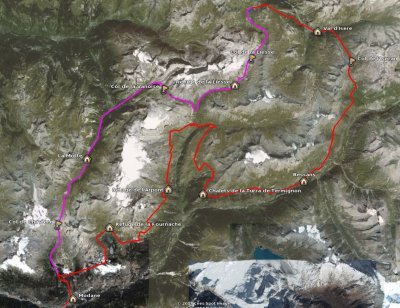
A rough idea of the route we followed - click to enlarge.


The landscape was fairly varied, featuring 4 main types:
  • Villages, towns and ski resorts (1,000 to 1,700m)
  • Forests (1,000 to 2,000m)
  • Alpine pastures (1,500m to 2,500m)
  • Semi-desertic high moutains (above 2,300m)
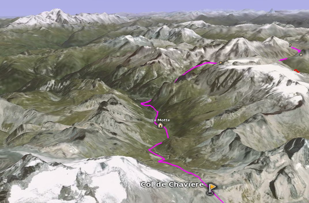
I've quickly put together a GoogleEarth route (*) of this hike showing the stages and the major cols. Some parts are not very precise, but it gives a good idea of the relief, as demonstrated on the following image.

Col de Chaviere 3D
A 3D view of the Col de Chavière from the South, with the Mont-Blanc in the background - click to enlarge.


Follows a brief outline of each hiking day.

Day 1: Modane - Refuge de la Fournache
After some storms during the first night, the weather was alright during the day with sunny intervals, a bit cold and windy though. After a 2-hour ascent in the forest we then arrived on the "balcony" at Polset.
First contact with the marmots and the Patous (or Pastous) dogs. These dogs are specifically grown to protect the sheep against the predators (wolves in the Alps, bears in the Pyrénées). At the difference of the shepherd dogs, they are part of the herd and the sheep are not afraid of them (they're actually taken away from their mother as they are puppies to achieve that). They're fairly big and a bit scary as they try to defend the sheep if they believe they're endangered (if you're too close, have sticks, run, take pictures, ...). But otherwise they're actually quite kind.
At the Refuge de la Fournache, we got the biggest meal ever in a refuge, nearly impossible to finish. Fortunately, the Génépi offered at the end helped digesting...
Rain in the evening that cleared during the night, beautiful morning.

Day 2: Refuge de la Fournache - Refuge de l'Arpont
After taking Rachel back down to Modane we came back up on the pastures. Very nice day, lots of marmots, views on the Ecrins (Pelvoux, Barre des Ecrins, Rateau). The GR 5 follows quite a lot this sort of balcony, avoiding to go down the valleys and up the Cols all the time.
At the Refuge de l'Arpont, we unsuccessfully tried to get a Mont-Blanc with génépi beer. As this refuge is inside the Park, it's only permitted to pitch the tent between 7pm and 7am. The area designated for the bivouac is actually quite small, many hikers unfold their tent on the ground to "book" their spot. At about 6pm, an helicopter from the gendarmerie (a sort of mix between police and army that is also doing rescue in the mountains) started to turn around the refuge. We were told to move everything away from the bivouac spot as quickly as possible, as it was the only place where the helicopter could land on. It was a bit messy to move everything quickly. Everyone expected a rescue. A guy came out of the helicopter, walked in the refuge, came out about one minute later and the helicopter left. We're not sure what was all that about ... Maybe they wanted to tell us off for unfolding the tents before 7pm. Or more likely, they wanted to get some Mont-Blanc/génépi beers, but the refuge has ran out, so they left ...
We saw a young ibex around, maybe the only one during the trip.

Marmot
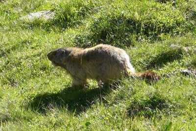
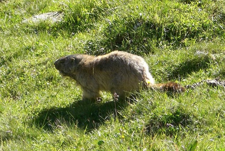
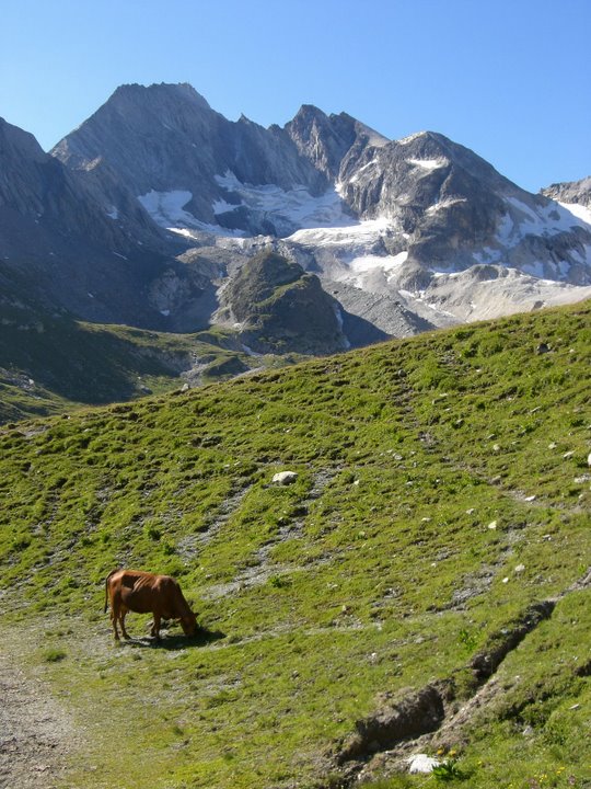
Marmot - click to enlarge


Day 3: Refuge de l'Arpont - Chalets de la Turra de Termignon
This was again a nice day, flirting with the high mountains, just under the glaciers. We went down to Entre-deux-Eaux, where we left the Tour des Glaciers de la Vanoise on the left. Then we climbed up again on a balcony, from where we got great views on the Dent Parachée and the Arpont.
We spent the night in the wild, outside the Park.

Day 4: Chalets de la Turra de Termignon - Bessans
The route on this day was not quite as great as the previous (and the following). We went back down to the forest and then to the villages in the Arc valley. The final 5km were quite boring and on top of that we had to doubled back once we learnt that the campsite was 2.5km backwards ...
At least we could have a shower and buy some food as we didn't get any opportunity so far.

Day 5: Bessans - Val d'Isère
The big day ! We climb up 1,500m to Col de l'Iseran and back down to Val d'Isère. This Col marked the passage to another valley, and the beginning of a series of ascent and descents. No flat balconies any more !
Rain was expected in the afternoon, and we planned to walk as long as it was dry. It was very windy and fairly cold approching the Col, but it didn't rain in the end, so we end up walking down to Val d'Isère, under the ski lifts. That was the second proper campsite in a row ! It eventually rained over night.

Col de la Liesse
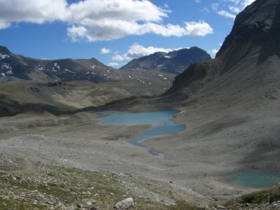
Col de la Liesse - click to enlarge


Day 6: Val d'Isère - Refuge de la Liesse
Sunny intervals in the morning, but windy and cold. We missed a view on the Mont-Blanc. Again, the path was following ski lifts most of the time.
After Val-Claret, we left the GR 5 for its so-called Alpine variation GR 55. Indeed it looked generally more remote from this point. The Col de la Liesse looks like a desert, with only stones and snow. Nice views !
Live accordeon music in the refuge. We met people that were walking part of the Via Alpina, that gave me some ideas for a (very) long-distance hike...

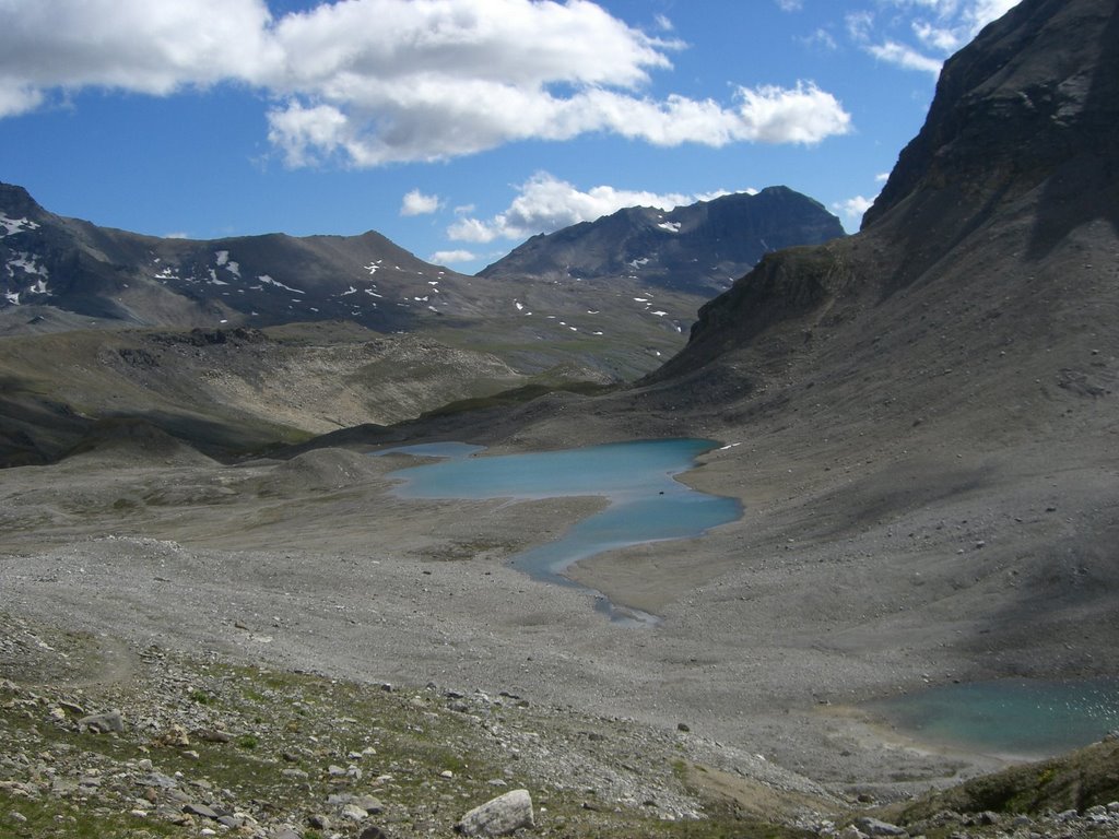
Day 7: Refuge de la Liesse - La Motte
Very cold morning, the tent was well frozen.
We walked down nearby to Entre-deux-Eaux where we caught up with the Tour des Glaciers de la Vanoise, then climbed up to the Col de la Vanoise. Great views on a couple of lakes.
Once we passed on the other side of the Col, the path was crowed with people, visibly going for a day hike from Pralognan-la-Vanoise. We walked down to Pralognan, made a bit of shopping and left following a very badly sign-posted path. For a GR, it was quite surprising. We went up a bit again towards the Col de Chavière, from where lots of hikers were going down after their day out. It was a tiring day, quite hard towards the end, as we didn't really know where to camp.

Col de Chaviere
Under the col de Chavière - click to enlarge


Day 8: La Motte - Modane
We finished the ascent to the Col de Chavière in the morning, early enough not to get too busy. A couple of marmots on the way were quite happy to be approached and photographed (see above). The final bit was quite desertic again, and a bit steep too. Part of the path were still on the snow. From there, their were amazing views towards the South (again: Pelvoux, Barre and Dome des Ecrins, Meije) as well as North (Mont-Blanc mountain chain). We then walked back down Polset (lots of exploded shells remaining under the Col). Then down through the forest to Modane - a nice 1,700m descent in total.

Col de Chaviere
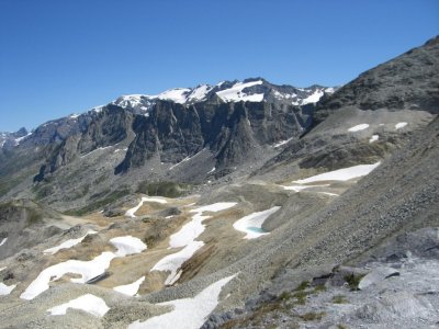
Col de Chavière - click to enlarge


Needless to say that we were extremely lucky with the weather. It rained the day before we arrived and it was raining in the morning we took the train back. It may well have been the only 9 consecutive days of sun in this part of the Alps for the whole summer, given the crap summer it's been over Europe this year.
Thanks to Bastien for those pictures. To get more, have a look at Bastien's album.

Ultra beautiful hike.

(*) You need to install GoogleEarth to read this file. GoogleEarth can be downloaded free of charge for Microsoft Windows (2000,XP,Vista), Mac OSX (10.4.0+) and GNU/Linux (i386) at this address: download GoogleEarth.

Sunday, February 26 2006

Strenuous winter hiking in North Wales

This week-end I went hiking in North Wales on my own.

I started on Saturday at lunch time from Llanfairfechan, on the North Coast. The weather was relatively good, the sun dominating on the clouds most of the time. Getting out of the commons was rather complicated, as the footpaths didn't exist anymore or were closed for the winter. So I spent hours climbing over stone walls... After a while, I arrived at Llyn (lake) Anafon. The snow started to cover most of the ground from this point, at around 500m high. I climbed up to the ridge and reached Foel-fras (942m). The snow was alternatively frozen (crampons would have been useful) or quite deep: snowboots and gaiters required, but I had none of them ! (*) Progression was therefore not as fast as expected. Then little by little, as I reached Garnedd Uchaf, the wind started to blow stronger and stronger. It was fundamentally not so cold (around -2°C), but with a wind that probably reached more than 50km/h at the end, it felt pretty cold I can tell ! See wind chill on wikipedia. I couldn't stay still for more than 5 minutes, and removing my gloves would have been a very bad idea !

To finish me off, the wind brought more and more clouds. Eventually, while approching Foel Grach (976m), I was completly in the clouds, with a visibility that didn't exceed 10m. I reckon I was not in the best situation. In that kind of conditions, it's very easy to get lost as you can't keep an eye on a landmark to orientate yourself. On top of that, reading the map was not easy because of the wind and the night was coming... At this point, my route was supposed to go downhill in between two cliffs. It was a really complicated position. I was walking, hoping to find big rock behind which I could pitch my little tent. The wind was stronger and stronger. Suddenly appeared just in front of me a kind of black open door, contrasting with the white everywhere else. It was Lloches Foel Grach Refuge, that you can see on this picture. It was really coming from nowhere, it's not even on the map ! I first thought I had some hallucinations. How could I find it just like that remains a mystery to me. I was very very lucky. Without this providential shelter what would have happened ? Would I have found a decent spot for my tent ? Would I have been able to pitch the tent ? Would my little ultra-light tent have resisted to the harrassing wind and the snow ? Would I have been able to light on the stove (no stove, no water) ? Lots of questions without answers...

Back to the refuge then. It's a small shelter of 3 meters by 2, built of stones. In this context, that's considered as a luxurious place to stay. Of course it was a bit cold and the drafts under the door and the shutter brought a nice quantity of snow inside during the night, building snowdrifts ;) But it was real luxury to be able to light on the stove easily, to sit down on a wooden bench and to sleep without wind ! I had a quick diner and went to "bed". I gave my new sleeping bag (TNF / Toundra) a first try. The thermometer gave -3°C in the refuge, exactly the comfort temperature rating of the sleeping bag :) (see temperature ratings). So I went in wearing only underwear. That was damn good ! It was really hot inside. And with a kind of light hood to cover the face, you even avoid the cold wind on the face, it's just great. Well, I can tell you I slept 13h in there :-D . Needless to say that the only problem with such a sleeping bag is to get out of it in the morning ...

After this long night, while preparing to leave, I had the typical winter problems: trousers, socks and shoes frozen... The weather was not much better as I hoped and I didn't wake up as early as expected. So I decided to follow a safer and shorter escape route (see how careful I am :) ). The wind was a bit weaker, though. After 10 minutes walking following my instinct, I felt like I couldn't get myself anywhere like that, so I started to navigate relying completely on GPS/compass/map. It's a bit strange to trust such a small electronic device. You can't see anything, you just know that there must be a cliff just on your right, that you should now turn left, and so on... It was quite strenuous, as the snow was sometimes as deep as my legs ! I eventually arrived at Tal-y-cafn. Da boch !

Ultra cold.

(*) Yes Kim, I didn't follow your advice... I'm sorry, I'll do it next time.

Tuesday, January 24 2006

Original ultra-feeling

On Saturday, Ludo, Fred and I walked from London (Hyde Park) to Weybridge, where Mommas lives. The 30km planned route follows the Thames and shortcuts a bit through Richmond Park and Bushy Park.

It's quite interesting that many aspects of an ultramarathon were visible here. It was particularly obvious with Ludo, as he was facing the unknown. Looking at how did the whole thing go helps me a lot to understand how people (and myself first) come to run ultras.
  1. A symbolic goal. Ludo actually came one day with the idea of walking from London to Weybridge. He had very little knowledge how far it was and how nice the route could be (and neither did I). No matter the route, start and finish cities took the first place. The first step towards ultra seems to find this kind of symbolic goal. For example the UTMB is a loop around the highest peak in Europe, which is highly symbolic. Furthermore, it's interesting to notice than during the UTMB 113 people withdrew at "La Fouly" (km102), wheras only 30 did it at "Praz-de-Fort" (km111), however easy the route is in between. That was the 100km symbolic effect. Most of the successful ultras carry such symbols.
  2. Back to Earth. To some extend, we just wanted to see whether it was possible to do on foot what everyone does by train/car. That's a kind of come back to the origins when humans had to walk. Nowadays we are nearly teleported by train from one city to another. Train windows give us very few idea of what is outside, whereas inter-city trips on foot build a physical link in between well-known places. London and Weybridge are now in the same world to us. Furthemore it's nice to realize you can walk or run what people do by car/train or even by plane for some happy few.
  3. Preparation. Preparation is crucial in ultra. Given the route, (too?) little credit was given to it this time. Only the typical thrill while looking at the distance on a map ;) ...
  4. Suffering. Last kilometers were rather long, due to nice blisters. But resistance to pain is the first quality of an ultrarunner... However, I've not heard any "I will never ever do it again". Should I conclude that this walk was not long enough ?
Although not particularly warm, the weather was very sunny (and we even walked by a garden with palm trees 8-) ):

good weather  palm trees
Among other curiosities, we saw many red deers in Richmond Park.

Ultra start.
Powered by