Tour du Parc National de la Vanoise
By Julien on Saturday, August 18 2007, 19:12 - Hiking - Permalink
Update 21/09: pictures and a bit of text.
A couple of weeks ago, Rachel, Bastien and I went to to the Vanoise National Parc for a bit of a hike. The Tour des Glaciers de la Vanoise is a classic in the region, we doubled it, as shown on the map below. The "outward" journey followed the virtually mythic GR5 from Modane to Val-Claret whilst the "return" used the GR 55 "alpine" variation in its full length. Unfortunately Rachel's knee was not so keen on the descents so she had to come back down with the ski lift just after one taster day.
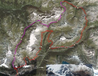
A rough idea of the route we followed - click to enlarge.
The landscape was fairly varied, featuring 4 main types:
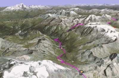
A 3D view of the Col de Chavière from the South, with the Mont-Blanc in the background - click to enlarge.
Follows a brief outline of each hiking day.
Day 1: Modane - Refuge de la Fournache
After some storms during the first night, the weather was alright during the day with sunny intervals, a bit cold and windy though. After a 2-hour ascent in the forest we then arrived on the "balcony" at Polset.
First contact with the marmots and the Patous (or Pastous) dogs. These dogs are specifically grown to protect the sheep against the predators (wolves in the Alps, bears in the Pyrénées). At the difference of the shepherd dogs, they are part of the herd and the sheep are not afraid of them (they're actually taken away from their mother as they are puppies to achieve that). They're fairly big and a bit scary as they try to defend the sheep if they believe they're endangered (if you're too close, have sticks, run, take pictures, ...). But otherwise they're actually quite kind.
At the Refuge de la Fournache, we got the biggest meal ever in a refuge, nearly impossible to finish. Fortunately, the Génépi offered at the end helped digesting...
Rain in the evening that cleared during the night, beautiful morning.
Day 2: Refuge de la Fournache - Refuge de l'Arpont
After taking Rachel back down to Modane we came back up on the pastures. Very nice day, lots of marmots, views on the Ecrins (Pelvoux, Barre des Ecrins, Rateau). The GR 5 follows quite a lot this sort of balcony, avoiding to go down the valleys and up the Cols all the time.
At the Refuge de l'Arpont, we unsuccessfully tried to get a Mont-Blanc with génépi beer. As this refuge is inside the Park, it's only permitted to pitch the tent between 7pm and 7am. The area designated for the bivouac is actually quite small, many hikers unfold their tent on the ground to "book" their spot. At about 6pm, an helicopter from the gendarmerie (a sort of mix between police and army that is also doing rescue in the mountains) started to turn around the refuge. We were told to move everything away from the bivouac spot as quickly as possible, as it was the only place where the helicopter could land on. It was a bit messy to move everything quickly. Everyone expected a rescue. A guy came out of the helicopter, walked in the refuge, came out about one minute later and the helicopter left. We're not sure what was all that about ... Maybe they wanted to tell us off for unfolding the tents before 7pm. Or more likely, they wanted to get some Mont-Blanc/génépi beers, but the refuge has ran out, so they left ...
We saw a young ibex around, maybe the only one during the trip.
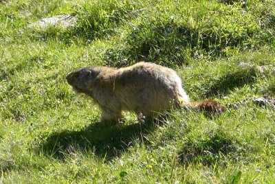
Marmot - click to enlarge
Day 3: Refuge de l'Arpont - Chalets de la Turra de Termignon
This was again a nice day, flirting with the high mountains, just under the glaciers. We went down to Entre-deux-Eaux, where we left the Tour des Glaciers de la Vanoise on the left. Then we climbed up again on a balcony, from where we got great views on the Dent Parachée and the Arpont.
We spent the night in the wild, outside the Park.
Day 4: Chalets de la Turra de Termignon - Bessans
The route on this day was not quite as great as the previous (and the following). We went back down to the forest and then to the villages in the Arc valley. The final 5km were quite boring and on top of that we had to doubled back once we learnt that the campsite was 2.5km backwards ...
At least we could have a shower and buy some food as we didn't get any opportunity so far.
Day 5: Bessans - Val d'Isère
The big day ! We climb up 1,500m to Col de l'Iseran and back down to Val d'Isère. This Col marked the passage to another valley, and the beginning of a series of ascent and descents. No flat balconies any more !
Rain was expected in the afternoon, and we planned to walk as long as it was dry. It was very windy and fairly cold approching the Col, but it didn't rain in the end, so we end up walking down to Val d'Isère, under the ski lifts. That was the second proper campsite in a row ! It eventually rained over night.
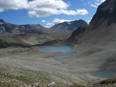
Col de la Liesse - click to enlarge
Day 6: Val d'Isère - Refuge de la Liesse
Sunny intervals in the morning, but windy and cold. We missed a view on the Mont-Blanc. Again, the path was following ski lifts most of the time.
After Val-Claret, we left the GR 5 for its so-called Alpine variation GR 55. Indeed it looked generally more remote from this point. The Col de la Liesse looks like a desert, with only stones and snow. Nice views !
Live accordeon music in the refuge. We met people that were walking part of the Via Alpina, that gave me some ideas for a (very) long-distance hike...
Day 7: Refuge de la Liesse - La Motte
Very cold morning, the tent was well frozen.
We walked down nearby to Entre-deux-Eaux where we caught up with the Tour des Glaciers de la Vanoise, then climbed up to the Col de la Vanoise. Great views on a couple of lakes.
Once we passed on the other side of the Col, the path was crowed with people, visibly going for a day hike from Pralognan-la-Vanoise. We walked down to Pralognan, made a bit of shopping and left following a very badly sign-posted path. For a GR, it was quite surprising. We went up a bit again towards the Col de Chavière, from where lots of hikers were going down after their day out. It was a tiring day, quite hard towards the end, as we didn't really know where to camp.
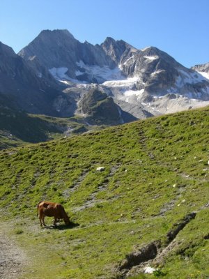
Under the col de Chavière - click to enlarge
Day 8: La Motte - Modane
We finished the ascent to the Col de Chavière in the morning, early enough not to get too busy. A couple of marmots on the way were quite happy to be approached and photographed (see above). The final bit was quite desertic again, and a bit steep too. Part of the path were still on the snow. From there, their were amazing views towards the South (again: Pelvoux, Barre and Dome des Ecrins, Meije) as well as North (Mont-Blanc mountain chain). We then walked back down Polset (lots of exploded shells remaining under the Col). Then down through the forest to Modane - a nice 1,700m descent in total.
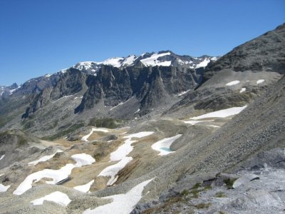
Col de Chavière - click to enlarge
Needless to say that we were extremely lucky with the weather. It rained the day before we arrived and it was raining in the morning we took the train back. It may well have been the only 9 consecutive days of sun in this part of the Alps for the whole summer, given the crap summer it's been over Europe this year.
Thanks to Bastien for those pictures. To get more, have a look at Bastien's album.
Ultra beautiful hike.
(*) You need to install GoogleEarth to read this file. GoogleEarth can be downloaded free of charge for Microsoft Windows (2000,XP,Vista), Mac OSX (10.4.0+) and GNU/Linux (i386) at this address: download GoogleEarth.
A couple of weeks ago, Rachel, Bastien and I went to to the Vanoise National Parc for a bit of a hike. The Tour des Glaciers de la Vanoise is a classic in the region, we doubled it, as shown on the map below. The "outward" journey followed the virtually mythic GR5 from Modane to Val-Claret whilst the "return" used the GR 55 "alpine" variation in its full length. Unfortunately Rachel's knee was not so keen on the descents so she had to come back down with the ski lift just after one taster day.

A rough idea of the route we followed - click to enlarge.
The landscape was fairly varied, featuring 4 main types:
- Villages, towns and ski resorts (1,000 to 1,700m)
- Forests (1,000 to 2,000m)
- Alpine pastures (1,500m to 2,500m)
- Semi-desertic high moutains (above 2,300m)

A 3D view of the Col de Chavière from the South, with the Mont-Blanc in the background - click to enlarge.
Follows a brief outline of each hiking day.
Day 1: Modane - Refuge de la Fournache
After some storms during the first night, the weather was alright during the day with sunny intervals, a bit cold and windy though. After a 2-hour ascent in the forest we then arrived on the "balcony" at Polset.
First contact with the marmots and the Patous (or Pastous) dogs. These dogs are specifically grown to protect the sheep against the predators (wolves in the Alps, bears in the Pyrénées). At the difference of the shepherd dogs, they are part of the herd and the sheep are not afraid of them (they're actually taken away from their mother as they are puppies to achieve that). They're fairly big and a bit scary as they try to defend the sheep if they believe they're endangered (if you're too close, have sticks, run, take pictures, ...). But otherwise they're actually quite kind.
At the Refuge de la Fournache, we got the biggest meal ever in a refuge, nearly impossible to finish. Fortunately, the Génépi offered at the end helped digesting...
Rain in the evening that cleared during the night, beautiful morning.
Day 2: Refuge de la Fournache - Refuge de l'Arpont
After taking Rachel back down to Modane we came back up on the pastures. Very nice day, lots of marmots, views on the Ecrins (Pelvoux, Barre des Ecrins, Rateau). The GR 5 follows quite a lot this sort of balcony, avoiding to go down the valleys and up the Cols all the time.
At the Refuge de l'Arpont, we unsuccessfully tried to get a Mont-Blanc with génépi beer. As this refuge is inside the Park, it's only permitted to pitch the tent between 7pm and 7am. The area designated for the bivouac is actually quite small, many hikers unfold their tent on the ground to "book" their spot. At about 6pm, an helicopter from the gendarmerie (a sort of mix between police and army that is also doing rescue in the mountains) started to turn around the refuge. We were told to move everything away from the bivouac spot as quickly as possible, as it was the only place where the helicopter could land on. It was a bit messy to move everything quickly. Everyone expected a rescue. A guy came out of the helicopter, walked in the refuge, came out about one minute later and the helicopter left. We're not sure what was all that about ... Maybe they wanted to tell us off for unfolding the tents before 7pm. Or more likely, they wanted to get some Mont-Blanc/génépi beers, but the refuge has ran out, so they left ...
We saw a young ibex around, maybe the only one during the trip.

Marmot - click to enlarge
Day 3: Refuge de l'Arpont - Chalets de la Turra de Termignon
This was again a nice day, flirting with the high mountains, just under the glaciers. We went down to Entre-deux-Eaux, where we left the Tour des Glaciers de la Vanoise on the left. Then we climbed up again on a balcony, from where we got great views on the Dent Parachée and the Arpont.
We spent the night in the wild, outside the Park.
Day 4: Chalets de la Turra de Termignon - Bessans
The route on this day was not quite as great as the previous (and the following). We went back down to the forest and then to the villages in the Arc valley. The final 5km were quite boring and on top of that we had to doubled back once we learnt that the campsite was 2.5km backwards ...
At least we could have a shower and buy some food as we didn't get any opportunity so far.
Day 5: Bessans - Val d'Isère
The big day ! We climb up 1,500m to Col de l'Iseran and back down to Val d'Isère. This Col marked the passage to another valley, and the beginning of a series of ascent and descents. No flat balconies any more !
Rain was expected in the afternoon, and we planned to walk as long as it was dry. It was very windy and fairly cold approching the Col, but it didn't rain in the end, so we end up walking down to Val d'Isère, under the ski lifts. That was the second proper campsite in a row ! It eventually rained over night.

Col de la Liesse - click to enlarge
Day 6: Val d'Isère - Refuge de la Liesse
Sunny intervals in the morning, but windy and cold. We missed a view on the Mont-Blanc. Again, the path was following ski lifts most of the time.
After Val-Claret, we left the GR 5 for its so-called Alpine variation GR 55. Indeed it looked generally more remote from this point. The Col de la Liesse looks like a desert, with only stones and snow. Nice views !
Live accordeon music in the refuge. We met people that were walking part of the Via Alpina, that gave me some ideas for a (very) long-distance hike...
Day 7: Refuge de la Liesse - La Motte
Very cold morning, the tent was well frozen.
We walked down nearby to Entre-deux-Eaux where we caught up with the Tour des Glaciers de la Vanoise, then climbed up to the Col de la Vanoise. Great views on a couple of lakes.
Once we passed on the other side of the Col, the path was crowed with people, visibly going for a day hike from Pralognan-la-Vanoise. We walked down to Pralognan, made a bit of shopping and left following a very badly sign-posted path. For a GR, it was quite surprising. We went up a bit again towards the Col de Chavière, from where lots of hikers were going down after their day out. It was a tiring day, quite hard towards the end, as we didn't really know where to camp.

Under the col de Chavière - click to enlarge
Day 8: La Motte - Modane
We finished the ascent to the Col de Chavière in the morning, early enough not to get too busy. A couple of marmots on the way were quite happy to be approached and photographed (see above). The final bit was quite desertic again, and a bit steep too. Part of the path were still on the snow. From there, their were amazing views towards the South (again: Pelvoux, Barre and Dome des Ecrins, Meije) as well as North (Mont-Blanc mountain chain). We then walked back down Polset (lots of exploded shells remaining under the Col). Then down through the forest to Modane - a nice 1,700m descent in total.

Col de Chavière - click to enlarge
Needless to say that we were extremely lucky with the weather. It rained the day before we arrived and it was raining in the morning we took the train back. It may well have been the only 9 consecutive days of sun in this part of the Alps for the whole summer, given the crap summer it's been over Europe this year.
Thanks to Bastien for those pictures. To get more, have a look at Bastien's album.
Ultra beautiful hike.
(*) You need to install GoogleEarth to read this file. GoogleEarth can be downloaded free of charge for Microsoft Windows (2000,XP,Vista), Mac OSX (10.4.0+) and GNU/Linux (i386) at this address: download GoogleEarth.
Comments
Great web site. Ill add it to mu ultra links page.
Phil