Hardmoors 110 elevation profile
By Julien on Tuesday, July 8 2008, 11:08 - Hardmoors - Permalink
The Ironman is now behind me and I'm turning my mind towards the Hardmoors 110. Whilst I'm resting physically, I'm already preparing for the race. I bought the Cleveland Way Footprint map, but the copyright dates back from 1991, so I'm not sure how accurate it is...
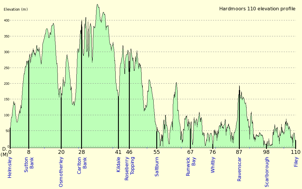
I've also traced the path on Memory Map, based on more recent Ordnance Survey information. That provides an insight on the ascent. Not that I didn't believe Jon when he told me it was about 6,000m in total, but I wanted to see its distribution along the path. The total ascent is about 5,700m... Not bad for a path that doesn't go much higher than 400m! This is because the path goes continuously up and down the hills. I'll have to focus my training on "quick" successions of up and downhill sections in order to be able to restart easily after each ascent.

Distances in miles as provided by the Hardmoors 110 roadbook (PDF).
Elevation in meters given by Memory Map, accuracy depends on hand-drawn trace.
Click to enlarge.
Update (07/08/2008): please find a more detailed profile with this entry: Hardmoors 110 detailed elevation profile.
As for the shoes, the Asic Gel Orient that carried me on my first UTMB start to show some tiredness signs. I'm going to replace them soon. I'm thinking about the Salomon XA Pro 3D Ultra. Any suggestions?
Ultra unexpected ascent.
I've also traced the path on Memory Map, based on more recent Ordnance Survey information. That provides an insight on the ascent. Not that I didn't believe Jon when he told me it was about 6,000m in total, but I wanted to see its distribution along the path. The total ascent is about 5,700m... Not bad for a path that doesn't go much higher than 400m! This is because the path goes continuously up and down the hills. I'll have to focus my training on "quick" successions of up and downhill sections in order to be able to restart easily after each ascent.
Distances in miles as provided by the Hardmoors 110 roadbook (PDF).
Elevation in meters given by Memory Map, accuracy depends on hand-drawn trace.
Click to enlarge.
Update (07/08/2008): please find a more detailed profile with this entry: Hardmoors 110 detailed elevation profile.
As for the shoes, the Asic Gel Orient that carried me on my first UTMB start to show some tiredness signs. I'm going to replace them soon. I'm thinking about the Salomon XA Pro 3D Ultra. Any suggestions?
Ultra unexpected ascent.