Running from Dover to Cape Wrath ?
By Julien on Wednesday, January 18 2006, 15:29 - Thoughts - Permalink
It's a bit of a crazy idea and I'm not sure I can do it (but whoever doesn't try can't fail (*)). I had this idea for a while now, I just wanted to share it and get some more comments. I still don't know when I will have the time and the legs to do it, maybe right after my PhD.
(*) and not: whoever doesn't trail can't fy...
In a couple of bullet points, the idea is the following:
The first challenge is obviously to finish. The second one, completely impalpable at the moment is how fast I can complete the diagonal, especially regarding to my knees, ankles and hips. One month is rather fast compare to a "typical" 3-month walk, but also very slow compared to the top runners, with assistance and on the road, that can run the Lands End to John O'Groats (the other diagonal that is longer) in around 9 days !
It's clear that I can walk 40km a day when the terrain is rather flat and not too technical (ie. 40 days). So for example if I swap continuously running and walking (one resting the other) I hope to reach 50 to 60km a day (ie. a total of 27 to 32 days). A fair daily objective would be:
8 x { 30min walking @ 5km/h + 30min running @ 10km/h } = 60km / 8h
If it is possible along the Grand Union Canal, I don't think I can keep up such a pace while crossing the North-West Highlands.
The route is not very well defined now. I don't particularly want to run the shortest way. Actually, I'd like to follow the national trail paths as much as possible.
Rough map (not accurate at all !):
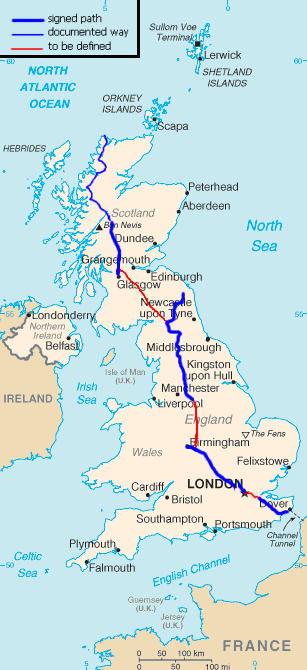
(The original image, that you can find on Wikipedia for example, is in the public domain.)
Regarding to the gear, I will need something in between hiking and trail running. Particularly ultra-light tent, sleeping bag and stove. I don't want to advertise too much, but RaidLight may be an interesting brand for that. I may also send some parcels to some 'relay' campsites on the way.
What do you think of that ? Interested ?
Ultra dream.
(*) and not: whoever doesn't trail can't fy...
In a couple of bullet points, the idea is the following:
- run from Dover to Cape Wrath: UK SE to NW diagonal
- solo except maybe some days where I could try to organise "run with me" events
- without assistance, nobody will follow me with a car - I will have to carry a tent and to buy some food on the way
- the distance will be around 1600km (1000 miles), mostly following national paths
- technically I will run & walk 50km/day - this should take a month
The first challenge is obviously to finish. The second one, completely impalpable at the moment is how fast I can complete the diagonal, especially regarding to my knees, ankles and hips. One month is rather fast compare to a "typical" 3-month walk, but also very slow compared to the top runners, with assistance and on the road, that can run the Lands End to John O'Groats (the other diagonal that is longer) in around 9 days !
It's clear that I can walk 40km a day when the terrain is rather flat and not too technical (ie. 40 days). So for example if I swap continuously running and walking (one resting the other) I hope to reach 50 to 60km a day (ie. a total of 27 to 32 days). A fair daily objective would be:
The route is not very well defined now. I don't particularly want to run the shortest way. Actually, I'd like to follow the national trail paths as much as possible.
| Dover to Medway Bridge | half of the North Downs Way | 86.5km |
| Medway Bridge to London Paddington | to be defined | ~52km |
| London Paddington to Birmingham | the Grand Union Canal (maybe quit around Coventry) | 233km |
| Birmingham (Coventry) to Edale | to be defined | ~160km |
| Edale to Kirk Yetholm | the Pennine Way (probably quit around Greenhead) | 315km |
| Kirk Yetholm (Greenhead) to Milngavie | to be defined | ~260km |
| Milngavie to Fort William | the West Highland Way | 152km |
| Fort William to Cape Wrath | North to the Cape | 326km |
Rough map (not accurate at all !):
(The original image, that you can find on Wikipedia for example, is in the public domain.)
Regarding to the gear, I will need something in between hiking and trail running. Particularly ultra-light tent, sleeping bag and stove. I don't want to advertise too much, but RaidLight may be an interesting brand for that. I may also send some parcels to some 'relay' campsites on the way.
What do you think of that ? Interested ?
Ultra dream.
Comments
You're crazy man !
But I think you can do it.
have you heard of matt hazely?
No I didn't. Thanks for spotting it to me !
Have you heard about Serge Girard ( en.wikipedia.org/wiki/Ser... ) ?